MONASHEE TOURISM
250-547-2300
Lumby
Cherryville & Mabel Lake
Hiking Trails
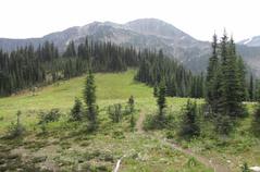
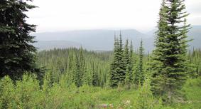
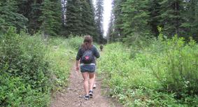
The Monashee Mountains boast some of the most spectacular hiking and backcountry ski areas in all of British Columbia. Walk through the Interior Rain Forests where the Cedar trees have stood for hundreds of years and the moss covers the forest floor. Follow the trails up to the Alpine meadows, jagged peaks and stunning white glaciers. With hundreds of kilometers of trails, the only footprints are yours.
Isn't it time, to refresh your life?!
Whether it's a walk for a day or an overnight backcountry trek here is a small sample of the trails in the Monashee. We hope you will enjoy these hikes and discover the natural beauty of Lumby and the Monashee area.
All hikers are encouraged to use extra caution when on the trails, due to frequent sightings of grizzlies and Black bears. The mountains are also home to Goats, Wolverines, Moose, Cariboo, Cougars and you never know, if your lucky enough, you might catch a glimpse of the ever so elusive Sasquatch.
Travel & Trek with Caution: The Monashee Mountain area represents Grizzly Bear Country
Monashee Provincial Park
The heart of the mountains of peace the monashee provincial park has great day and overnight treks ranging from easy to difficult. .
Monashee Provincial Park was established in 1962. The Park is situated east of Lumby and north of Cherryville, in the heart of the southeast central Monashee Mountains. To reach Monashee Provincial Park, follow Hwy. 6 east of Lumby to Cherryville. Turn left onto Sugar Lake Road (look for Frank's General Store) and proceed 48 kilometers until you reach the turnoff for the Park. Travel another 3 kilometers and you will have reached the parking lot.
The park is comprised of 7, 513 hectares, and has approximately 30 kilometers of well maintained trails, and offers a choice of 10 wilderness campsites and 6 overnight shelters, as well as, a group site at Spectrum Lake. Each of the campsites provide picnic tables and pit toilets.
Monashee Park's beautiful lakes are teeming with Rainbow Trout. the waters of Peters, Margie and Spectrum Lakes are a fisherman's paradise.
The highest of the parks peaks is Mt. Fosthall, reaching 2,679 meters, and overlooks the wilderness below. Monashee Park will appeal mainly to the experienced hiker, but still remains suited to the range and abilities of willing beginners. In certain places the terrain can be very steep and the going difficult. Some of the names given to the area are indicative of this; S.O.B. Gulch and Belly Up Canyon to name a couple. The park features some of the oldest rock formations in Western Canada.
Springtime transforms the high alpine meadows into a sea of wildflowers; lupine, daisies, fireweed, lilies, monkey flowers and columbine. The landscape becomes a living tapestry, rich with hues of blue, gold, crimson and green.
The park protects substantial stands of old growth cedar, spruce, hemlock and many untouched watersheds.
Wildlife is abundant and varied. Visitors regularly see deer, marmots, squirrels, rabbits and black bear. The higher elevations provide homes for some of the more elusive and threatened species, including woodland caribou, pika, mountain goats and of course the grizzly bears.
Spectacular vistas, clean mountain air and sparkling lakes are all yours to discover. The rewards are well worth it.
Because the park is home to the grizzly bears there are no dogs allowed inside the Park boundaries. Stop at the Lumby Info Centre to pick up a detailed map of the park.
EASY Trails
**Trails classified as EASY are highly maintained trails which are generally flat with gradual incline, suitable for all ages and skill levels.**
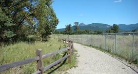
LUMBY SALMON TRAILS
-Weyerhaeuser Lumby-
These scenic trails follow Bessette and Duteau creeks, the easternmost spawning grounds of Pacific coho and chinook salmon. There are three trails connected via downtown streets. Each trail has information, art and activities on a different theme. The different environments you find along the trails ranging from the Cottonwood riparian habitat to the industrial land that is indicative of Lumby's association with forest products provide interest for all tastes. The trails are a first step towards developing a harmonious coexistence between industry and our natural environment. The numerous murals along Lumby's downtown streets further exemplify this community in transition.
Itineraries as short as 1 km and as long as 8 km are offered on terrain that is flat and accessible to wheelchairs, prams and bicycles. To get the most out of. your visit, start at the kiosk located behind the visitor centre where you can obtain a trails passport and a children's activity guide. Please stay on the pathways and bring your sunglasses and a hat to make it easier to see into the creeks and trees. Your leashed pet is welcome and doggie bags are provided.
The coho and chinook salmon that are born and grow in these creeks travel more than 1,000 km from the Pacific Ocean to come back to spawn! They may not always be visible but the salmon are present throughout the year, either as eggs in the gravel, juveniles behind logs, or as spawners. In addition to the creek life, you may see eagles and hawks soaring on high or spiders and snails creeping along!
Although spawning occurs only in late summer and fall, the interpretive signs, activities and scenery make the trails interesting and fun for everyone at any time of the year. Touch and play activities will interest young children while puzzles and discovery points will captivate the attention of older children and adults. Benches provide frequent resting spots while picnic tables make the trails a perfect spot for a snack.
The trails are an ideal location to hold events such as benefit races, bird counts, community walks, and group and school outings. Children's guides and other informational brochures will be provided upon request. For help in planning your event or to take part in one of the several year round events occurring on the trails contact us at lumbychamber@shaw.ca, or phone 250-547-2300, and visit www.lumby.ca/salmontrails.
The building of these trails has been a community effort. The Village Of Lumby built them with funding from the Government of Canada, Weyerhaeuser, and in collaboration with the Okanagan Indian Band, local industry and landowners. The wonderful, ongoing contributions of school students and teachers, clubs and individuals make the trails unique and ensure that there will always be more to see!
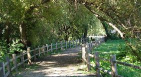
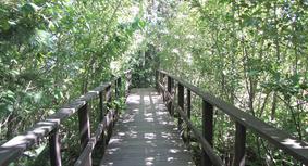
INTERPRETIVE TRAIL
-MABEL LAKE PROVINCIAL PARK-
Starting from the Mabel Lake Provincial Park's day-use parking lot, the short, 1 km "Changing Rainforest" self-guided interpretive trail winds through the shaded forest carpeted in moss that is found between the campsites and the main road. It is a gentle hike taking visitors through the maturing second growth rainforest of western red cedar, hemlock and some Douglas fir. The hike takes 30 minutes.
MYSTIC TRAIL
-GYRO CLUB AT MABEL LAKE-
Travel north on Mabel Lake Road and follow this paved road for 36 kilometres. The road then turns to gravel and an additional 14.5 kilometres, one bidge and a cattle guard will get you to the trailhead. Located at approximately 15 1/2 forestry kilometre marker there will be another small bridge. Parking near the bridge the trailhead is located on the Lumby side of the bridge and is marked by a shoe tree. this is a short 10 - 15 minute walk through an Enchanted Forest inspired trail.
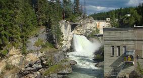
SHUSWAP FALLS
-BC HYDRO SHUSWAP RIVER-
Shuswap Falls at the Wilsey Dam site is an excellent place for a picnic. You may take a walk on several trails and observe a working hydroelectric dam. Shuswap Falls is a maintained BC Hydro Recreation site with a parking lot, picnic tables, interpretive signs, and pit toilets. There is a great viewing platform that overhangs the spillway offering a 'bird's-eye-view' of the falls and dam. During the spring runoff the roar of the water can be heard from quite a distance. To travel to the Shuswap Falls Recreation site from Lumby, head north on Shuswap Avenue, the name of the road changing to Mabel Lake Road on the outskirts of the Village. Follow Mabel Lake Road for 15 km from Lumby to a bridge that crosses over the Shuswap River. After crossing the bridge, drive another 500 metres to the turnoff on your left. The parking lot gate is open from May to October, 8:00 am to 8:00 pm.
MEDIUM Trails
**Trails classified as MEDIUM are non-maintained trails with moderate to steep incline, suitable for average to intermediate skill levels. May have narrow and slippery sections.**
CAMEL'S HUMP
-Creighton Valley-
Only accessible with 4 wheel drive
Traveling east from Lumby on Hwy. 6, the first road on the right after the amber flashing light is Creighton Valley Road. Turn onto this road and follow it for approximately 15 km, until you reach Clier Lake Road on the left. Follow this road and the directional signs until it ends at the parking lot. Follow the signs to the trailhead. The trail travels up the first hump, down into a valley, and up the second hump.
This is a fairly easy hike, which covers about 6 kilometers, and takes about 2-and-one-half hours. There is a gain of approx. 630 meters, with the top of the peak reaching about 1,200 meters. You will get a good view of the Creighton Valley on your left, and Lumby on the right.
About the Camels Hump
The Camel's Hump forms the geographical backdrop to Lumby and the Whitevalley area. Readily visible from the Kalamalka Lookout on Hwy. 97 south of Vernon, the Camel's Hump rises to an elevation of 1331 meters (4336 feet) above sea level.
An erosional remnant of the Kamloops Group, it is comprised of predominately basaltic lavas and flow breccias. The lavas are the geographical deposits representing the last volcanic period in this area. The glaciers sculpted the cliffs during the Pleistocene ice age.
An article from the Provincial Archives in Victoria dated 1867 makes reference to the "Camel's Back". The early gold rush miners moving northward through the Okanagan Valley used camels as pack animals, and since the mountain bears a striking resemblance to the twin humps of the bactarian camel, it is easy to see why the miners named this Camel's Hump. Some of the original Okanagan stories refer to the mountain as Coyote Sleeping. Today if you view the rock cliffs from an north eastern direction you can clearly see the coyotre curled up in the rocks. Hiking trails approach the summit along a fairly gentle slope from the south side via Creighton Valley Road, or you can tour around the Camel's Hump on an easy self-guided drive. Or if you would like to experience the fantastic views from the top of the hump ask for a Top of the Hump Hiking Trail Map.
EAGLE CREST CLIFFS
-Creighton Valley - Cozy Cabins-
This 3 hour round trip hike is winding through a forest which leaves you in awe at the huge firs and cedars still standing. Once you start the climb up the south face of the Creighton Valley you will see and experience one of the most diverse microclimate in the area. The snowfall in the winter and the abundance of warm sunshine in the summer creates a large diversity of southern BC's fauna and flora all in one small region. The wildlife enthusiast will experience everything from Ponderosea Pine to Cedars, as well as a large variety of shrubs and wildflowers common to the area. Once you have reached the Eagle Crest Cliffs, you will be rewarded by the views of a soaring eagle. Barbe Lake, Echo Lake and cozy Cabins Nature Resort's small lake can all be seen from these upper cliffs. This will be a very rewarding hike with easy access from Creighton Valley Road.
From Lumby, travel east on Creighton Valley Road for 19km. You can park at Cozy Cabins Nature Resort and obtain a hiking map from the operators of the resort, or pick one up from the Lumby Visitor Centre.
KATE LAKE
-Kate Creek Forest Service Road Sugar Lake-
This pristine lake is set in a mountain bowl, surrounded by forested hills. To get there, just drive east from Lumby to Cherryville. Follow Sugar Lake Road approximately 15 kilometers, until you reach Kate Lake Forestry Service Road on your right hand side. Follow this road for approximately 2 kilometers, where you will take the right hand fork. At 2.5 km, 3.5 km, and 8.2 km keep left. At 11.2 km you will drive past the road to Sitkum Lake. Stay right at the following junction, then keep left for the next 3 junctions. Now you will cross Sugar Creek, and about 100 meters past the bridge you will turn right. This road is 4 x 4 only! It is possible that you will have to walk the 5.5 km to the trailhead, as this road is very rough. The trailhead is clearly marked on the left hand side.
From here it is a short 2.5 km hike to the lake.
Altogether this is an 8 km hike, which takes approximately 2 hours. your final altitude will be 1,500 meters, with a gain of 600 meters.
PINNACLES LAKE
-South Fork Road Cherryville-
The Pinnacles is a popular hike with the locals. It is accessed off South Fork Road, 26.5 kilometers east of Lumby on Hwy. 6. Turn left onto South Fork Road, and at 2.3 kilometers and 6.2 kilometers keep to the right, then at 12.5 kilometers and 15.3 kilometers keep to the left - make sure not to cross Monashee Creek! At 18 kilometers keep right to reach the Pinnacles. At approximately 23 kilometers you will find the trailhead signs. Follow the cow trail into the woods, and watch for the red ribbons marking the trail. Experienced hikers will find many day-hikes from here, while the beginners may be content to relax next to the pristine glacier fed lake. The altitude is approximately 1900 meters, with a gain of about 700 meters. These hikes cover a distance of 4.5 kilometers, with a hiking time of about 2 hours.
RIM ROCKS
-King Edward Forest Service Road-
The Rim Rocks are a geological oddity that is definitely worth the long walk up the gravel road to see. Made of old volcanic material, the Rim rocks appear as an alien landscape amongst the cedars and pines of the surrounding forest. The hillside appears to have simply fallen away from the rest of the area leaving a massive rock pit almost devoid of life save for a few stubborn trees who seem to grow out of bare rock. The Rim rocks trail leads you along the edge of this rock pit with sheer drop of nervous proportions. Over thousands of years since the lave was deposited, the earth has eroded to form huge spires 50 or 60 feet tall which stand guard over the barren rocks below. For experienced hikers wearing proper footwear, the trail has a side route that leads down a very steep slope. This trail leads through a hole that is formed where a giant boulder is nestled between the two sides of a break in the rocks known as the "eye of the needle". The trail leads down into the rock pit, where it ends.
15km west of Lumby, turn south on King Edward forest service road (look for a large open gravel pit). Follow King Edward FSR for approximately 4km and turn on the side road where the main road branches to the right. At 1.5km on this side road, look for a hiking trail sign post on the right near a gated side road. Park near this gate, as this is the road that leads to the trailhead. it is approximately a 2km walk on a disused gravel road with a steady uphill incline to get to the Rim Rocks signpost at the top.
ROTTACKER LAKE
-Kate Creek Forest Service Road Sugar Lake-
Drive along Sugar Lake Road about 15 kilometers from the turn off Highway 6 until you reach the Kate Creek Forest Service Road. Follow this road for 20 kilometers, and you will reach the Rottacker Lake trailhead. This 3 kilometer hike is rough and "brushy", but is suitable for the willing beginner.
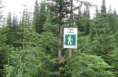
TWIN LAKES
-North Fork Road Cherryville-
Drive east from Lumby on Hwy. 6, approximately 22 km, to the North Fork Road turnoff. Turn left and drive up this road to the end (approx. 20 km), and turn onto Severide Creek Road. Continue down this road until you come to the parking lot, which also has an outhouse and the Twin Creek Lakes hiking trail sign. This is a 6 kilometer hike, which takes about one-and-a-half hours.
YEOWARD MOUNTAIN
-South Fork Road Cherryville-
Drive east from Lumby on Hwy. 6, turning left on South Fork Road. After 2.5 kilometres turn right onto Yeoward Mountain Service Road keeping left for the next 13 kilometres. At the top of the hill turn right (about 14km on Yeoward Rd) and look for a rock cut-road on the left. Park here and begin your hike. Hike up the cut-road and follow the old road about a 1/2 km up. This is a 6km hike and takes about 3 hours. the Altitude is about 2128 metres with a gain of 700 metres.
MODERATE Trails
**Trails classified as MODERATE are non-maintained trails with gradual incline, suitable for beginner to intermediate skill levels. May have narrow and slippery sections.**
CASCADE FALLS
-Mabel Lake-
To get to Cascade Falls from Lumby, travel north on Mabel Lake Road and follow this paved road for 36 kilometres through a picturesque landscape of farmland and ranches. The road then turns to gravel and an additional 14 kilometres, located at the 15 1/2 forestry kilometre marker, will take you to Cascade Falls which is not marked. The trailhead and parking area are located on the right hand side of a hairpin turn. The trail is generally in very good condition and is about a 5 to10 minute walk. The grade is moderate and winds through a moss-lined gully along a crystal clear stream. There are picnic tables and a pit toilet on site.
While travelling to Cascade Falls, you will pass Shuswap Falls and Mabel Lake Provincial Park. The park contains a number of clean, sandy beaches, a playground, and walking trails. The parking lot for Cascade Falls is 13 km past the turn off to the Mabel Lake Provincial Park.
BLUENOSE MOUNTAIN
-Lavington-
From Lumby, drive west towards Vernon and turn left onto School Road in Lavington. At the end of School Road, you will reach Learmouth Road. Turn left and follow Learmouth up the hill to a T-junction. Now turn left onto Aberdeen Road - Bluenose Mountain is straight ahead. 4 km up the mountain you will come to a cleared area on the left, and you will see a hiking sign near the roadside. Park here and start your hike.
Go into the timber at the top of the clearing, and step over the log barrier. Follow an old track up the hill until you reach the trailhead sign on your right hand side. The trail comes to a junction where the left hand fork leads to the first peak of Bluenose, while the right hand fork leads to the third peak. The second peak of Bluenose is private property, and there are no public trails leading to it. Both peaks offer splendid views of Whitevalley and Lumby. This is an easy 2-hour hike, which covers approximately 5 kilometers. The final altitude is 1199 meters, with a gain of 200 meters. This hike is well suited for beginners.
DENISON LAKE
-Creighton Valley-
This 6 hectare fishing lake is at an elevation of approximately 1,460 meters. From Lumby, travel east to Creighton Valley Road. Turn right onto Creighton Valley Road and drive almost to Barb Lake, about 15 kilometers. Turn right onto the Bonneau Forest Service Road and follow it to the trailhead. This 2 kilometer hike is fairly easy and is well suited for beginners. Be sure to watch for some spectacular rock formations along the way.
RAINBOW FALLS
Monashee Provincial Park
Rainbow Falls is approximately 70 km from downtown Lumby. To visit Rainbow Falls from Lumby, drive 22 km east on Hwy 6 and turn left onto Sugar Lake Rd at Frank's General Store. From Frank's Store travel an additional 24 km to reach Sugar Lake. Cross the bridge and drive an additional 22 km further on the gravel road. Turn right at 22 km onto Spectrum Creek Road where signs are visible pointing to Monashee Provincial Park. After driving another 3 km towards Monashee Provincial Park, you will see the turn-off to the falls on your left. Travel ½ km to the Rainbow Falls parking lot where you will see the trailhead leading to the falls. The trail down to the falls is approximately a 5 to 10 minute walk and in excellent condition, but watch your step, as there may be some slippery sections along the way. This is the original trailhead to Spectrum Lake, but is now mostly used to view Rainbow Falls and the old growth cedar forests.
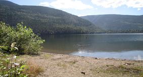
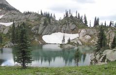
SPECTRUM LAKE
-Monashee Provincial Park-
Spectrum Lake is the main camping area located 6 km from the Spectrum Creek trailhead at the Monashee Provincial Park Parking lot. There are 16 sites are spread out along the lakeshore and up the slope towards the Ranger Cabin. Each site has a ten foot by ten foot wooden tent platform, fire ring and picnic table. Most of the sites along the lake also have a small wooden shelter with cedar shake roof over the picnic table. Cedar, hemlock and Douglas fir are found throughout the camping area offering plenty of shade and providing a backcountry experience for novice hikers. The understory is sparse, with most of the ground carpeted by moss. A metal food cache pole is located at each end of the campground. They are 20 feet high with cables attached for stringing up food and backpacks.
SUGAR MOUNTAIN
-Kate Creek Forest Service Road Sugar Lake-
This 7 kilometer hike leads to an old lookout on Sugar Mountain. The trailhead is at the start of an old 4-wheel access road at the 21 kilometer mark on the Kate Creek Forest Service Road, just past Sugar Creek. It is a suitable hike for beginners, but be cautious of grizzly bears in the area. The lookout provides some awesome views of the valleys below.
HARD Trails
**Trails classified as HARD are non-maintained trails and have steep incline, suitable for intermediate skill levels. **
LITTLE PETERS LAKE
-Monashee Provincial Park-
Follow the directions to Spectrum Lake then continue a further 6 km along the trail and you will reach Peters Lake. This is a difficult 3-and-a-half hour hike. Peters Lake makes a good base camp for many day hikes. You can continue onto other campsites at Margie, Mike and Fawn Lakes to name a few.
VISTA PASS & BARNES CREEK
-South Fork Road Cherryville-
This is a 16 km hiking trail to the South Pinnacles Ridge. Turn left onto South Fork Road off Hwy. 6, 26.5 km east of Lumby. Follow the directions to the Pinnacles, but at 23 km, don't stop. Just a couple of kilometers further will bring you to the trailhead. The trail is found on the north side of the creek.
This trail meets up with the Barnes Creek Trail, which is an 8 km horseback riding/hiking trail. You can also reach the Barnes Creek trailhead by turning onto the logging road to Keefer Lake, 60 km east of Lumby on Hwy. 6. Continue past Keefer and Holmes Lakes to a 4-wheel drive road. This is a scenic trail with a great view of the Pinnacles.
VIDLER'S RIDGE
-Kate Creek Forest Service Road Sugar Lake-
Drive east from Lumby to Cherryville. Follow Sugar Lake Road approximately 15 kilometers, until you reach Kate Lake Forestry Service Road on your right hand side. Follow this road for approximately 2.5 kilometers, where you will take the right hand fork. At 9.5 km you will drive across the Outlet Creek bridge go up the hill to the left. Stay to the left until you cross another bridge. Now you take a sharp right making sure that you are continuing uphill as there are three roads at this junction. After 1.6km park on the side of the road and the trailhead should be on the lefthand side of the road. The trail is fairly easy to follow though it can be quite steep and there may be water and muddy sections along the trail.
Vidler's Ridge is a 14km hike which takes a good 6 hours to do, with an altitude of 1,980 meters, with a gain of 400 meters.
DIFFICULT Trails
**Trails classified as DIFFICULT are non-maintained trails and have steep incline, suitable for experienced skill levels.**
BEAVEN MOUNTIAN
-South Fork Road Cherryville-
This 7 km trail is located on South Fork Road (on your way to the Monashee Lake trailhead). 18 km up South Fork Road, turn left as if you were going to Monashee Lake. A few kilometers from this turn-off, turn left again and drive to a logged area, where you can park. From here you can see the trailhead to Beaven Mountain.
MONASHEE LAKE
-South Fork Road Cherryville-
Monashee Lake is accessed off South Fork Road, 26.5 kilometers east of Lumby on Hwy. 6. Turn left onto South Fork Road, and at 2.3 kilometers and 6.2 kilometers keep to the right, then at 12.5 kilometers and 15.3 kilometers keep to the left - make sure not to cross Monashee Creek! At 18 kilometers keep left to reach the Monashee trailhead. At approximately 24 kilometers you will find the trailhead signs. Follow the cow trail into the wood, and watch for the red ribbons marking the trails. Experienced hikers will find many day-hikes from here, while the beginners may be content to relax next to one of the pristine glacier fed lakes.
The altitude is approximately 1900 meters, with a gain of about 700 meters. This hike covers a distance of 4.5 kilometers, with a hiking time of about 2 hours.
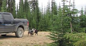
SITKUM LAKE & GOAT MOUNTAIN
-Kate Creek Forest Service Road Sugar Lake-
Drive east from Lumby to Cherryville. Follow Sugar Lake Road approximately 15 kilometers, until you reach Kate Lake Forestry Service Road on your right hand side. The road to Sitkum Lake is accessed 11 kilometers along the Kate Creek Forest Service Road. Follow the Sitkum Lake Forestry Road for an additional 12 kilometers, and you will reach the trailhead to Sitkum Lake/Goat Mountain.
This 8 kilometer sub-alpine trail has some steep, rocky areas, and is therefore recommended for experienced hikers only!
TSUIUS MOUNTAIN
-Sugar Lake-
Follow Sugar Lake Road for approximately 49 kilometers from Highway 6. Turn left just past the turn-off for Monashee Provincial Park, and follow the signs to the trailhead. This sub-alpine hiking area is difficult hiking, and is recommended for experienced hikers only! There are trailheads at Tsuius Creek, Tourmaline Creek, and just east of Mirror Lake (the most popular). This is approximately a 6-hour hike, but longer ones may be arranged.