MONASHEE TOURISM
250-547-2300
Lumby
Cherryville & Mabel Lake
Lakes & Waterfalls
The Monashee has an abundance of fresh water. Here pristine waters can be found being fed by glaciers and clear mountain streams.
Glaciers in the Monashee provide the source for the Shuswap River one of the great river systems in British Columbia which eventually feeds the Fraser River.
The Aberdeen and Graystokes Plateaus above Lumby and Cherryville represent a vast wetland area dotted with lakes which feed Okanagan Lake, eventually draining into the mighty Columbia River.
In fact, a small hill on Highway 6 just west of Lumby can provide visitors with the expreience of standing at a place where one foot can be placed in the Fraser Watershed, and the other in the Columbia.
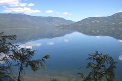
ECHO LAKE
One of the most picturesque emerald green lakes in Western Canada is situated 22 km southeast of Lumby on Creighton Valley Road.
Echo Lake is 165 feet deep, and rests at the edge of the Monashee Mountains. This spring fed lake is approximately 4 kilometers (2 1/2 miles) long, and 1 kilometer (.6 miles) wide.
Echo Lake is stocked every year with 20,000 fish for recreational fishing. Even the most inexperienced fishermen will enjoy the chance to catch Rainbow and Lake Trout, Gerards, and Kokanee. To maintain the tranquillity of the area, boat motors are restricted to 10 H.P.
Vacationers can join the locals for refreshing swims, canoeing or picnicking during the summer months. During the winter Echo Lake is a popular attraction for ice fishing.
KEEFER LAKE
Are you looking for great fishing, memorable trail rides, scenic hiking or perhaps mountain biking?
What about a refreshing dip in a cool mountain lake?
As a winter lover, perhaps you are seeking exciting snowmobiling, an invigorating cross country ski, or a day out ice fishing? Keefer Lake offers all this and more to the adventuresome traveler.
Keefer Lake is located 90km east of Vernon on Highway 6. Pass Lumby and Cherryville then look for the big sign at the Monashee Pass summit. The road into Keefer Lake is 14km and is usually well graded and free of washboards all year round. It is also used by logging trucks so please observe all signage and use caution.
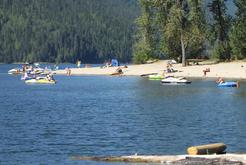
MABEL LAKE PROVINCIAL PARK
Well off the beaten path. Nestled in a beautiful mountain setting, you'll find the sandy beaches and lush forests of Mabel Lake Provincial Park.
Fishing enthusiasts will find the lake generous year-round, with large Rainbow Trout, Kokanee, Lake Trout and Dolly Varden. In the late summer, special Chinook fishery openings often provide opportunities to catch the big ones.
The 187 hectare park on the southeastern shores of Mabel Lake can be accessed several ways. Turn off Hwy. 97 onto Hwy.6 at Vernon for a scenic drive. Upon entering Lumby, at the red flashing light in the center of town, turn left and follow Mabel Lake Road north to the park.
Paved all the way except for the last half km, this 60 km route winds through a picturesque landscape of orchards and farmlands into Shuswap Highlands. The Park may also be accessed via paved and gravel road from Enderby and the north Mabel Lake area, or, for braver travelers, via a very rough gravel road from Three Valley Gap on Hwy. 1. Be sure to watch for heavy commercial vehicles on both alternate routes...and drive safely.
Friendly staff keep the park's facilities well-groomed and spotless from mid-April through October. Eighty-one campsites, a group camping area and extensive picnic grounds are tucked into a natural forest canopy, with large open play areas and 2,100 m of sandy beach. Special tent pads, sani-station, children's playground and self-guided nature trails enhance your enjoyment of the park, while a boat launch provides easy access for hours of fishing, water skiing, or just exploring the 35 km undisturbed shoreline along Mabel Lake.
SUGAR LAKE
Sugar Lake lies in comparative isolation, surrounded by the rugged beauty of the Monashee mountains.
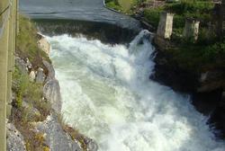
A tourist lookout at the lower end of the lake provides visitors with an ideal advantage point to view Brenda Dam, and the river and pools below. Lake fishing is fair through most of the summer and fall, yielding primarily Trout and Kokanee, though larger Trout and Dolly Varden can also be caught.
During the hot summer months, the lake water warms enough for a refreshing swim. Numerous hiking trails from the lake to the upper river will provide hours of pleasure for both the beginner and experienced hiker.
To reach Sugar Lake, take Hwy. 6 east from Lumby to Cherryville. At Frank's General Store turn left onto Sugar Lake Rd. From this turnoff, most of the 16 km of road is paved, the remainder is good gravel.
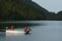
SHUSWAP RIVER
Lake canoeing in any of several lakes in the Lumby area offers a prime opportunity to observe waterfowl and the population of osprey along the water's edge. Both Mabel Lake and Sugar Lake offer canoeists many secluded beaches off the beaten track.
If a bit of white water is what you are looking for, B.C.Hydro operates a canoe launch on the Shuswap River. This launch is complete with picnic tables, and a large map of the canoe route between Sugar Lake Dam and Mabel Lake.
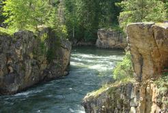
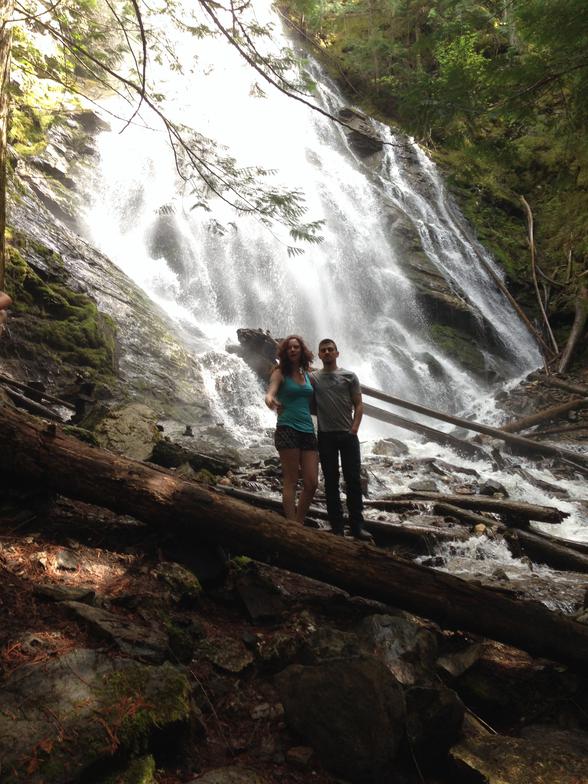
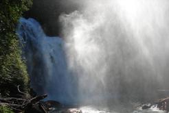
WATERFALLS
If you like to listen to the roar of water tumbling over rocks and have a cool sparkling mist collect on your face, you may want to visit one of four waterfalls to be found in the Lumby area. Three of the waterfalls are located on the pristine Shuswap River and the fourth is located close to Mabel Lake Provincial Park.
BRENDA FALLS
Brenda Falls is located on the way to Sugar Lake. From Lumby drive 22 km east on Hwy 6 and turn left onto Sugar Lake Rd at Frank's General Store. From Frank's Store travel an additional 24 km to reach Sugar Lake and when you cross the bridge at Sugar Lake, drive 200 metres and turn left on Rieter Creek Rd. Follow the road until you reach the first fork in to road about 1/2 km. Taking the left fork you will shortly come to a gate which says that you cannot park infront of it. Park shortly before the gate pulling off to the side as much as possible. Walk around the gate and follow the road to the old parking lot near the river. You may view the falls from the parking lot or choose to access a viewing area below the falls. The trail is not marked but is located through the trees and views the lower part of the falls. This trail is short and quite steep. A secondary view point can be found on Sugar Lake Rd on the left hand side before you come to the bridge. This is clearly marked with a BC Hydro Sugar Lake Dam Viewpoint Sign. Park on the side of the road in the small gravel area and walk through the gate into the picnic area. You can view the dam from the picnic area or there is a steep gravel trail that goes down to the dam level for better viewing.
CASCADE FALLS
To get to Cascade Falls from Lumby, travel north on Mabel Lake Road and follow this paved road for 36 kilometres through a picturesque landscape of farmland and ranches. The road then turns to gravel for an additional 14 kilometres. Located at the 15-1/2 forestry kilometre marker, you will find the unmarked trail head which will take you to Cascade Falls. The trailhead and parking area are located on the right hand side of a hairpin turn. The trail is generally in very good condition and is about a 5 to10 minute walk. The grade is moderate with winds through a moss-lined gully along a crystal clear stream. There are picnic tables and a pit toilet on site.
While travelling to Cascade Falls, you will pass Shuswap Falls and Mabel Lake Provincial Park. The park contains a number of clean, sandy beaches, a playground, and walking trails. The parking lot for Cascade Falls is 13 km past the turn off to the Mabel Lake Provincial Park.
RAINBOW FALLS
Rainbow Falls is the longest drive at approximately 70 km from downtown Lumby. The trip, however, is definitely worth it as is evident when you enter the headwaters of the Shuswap watershed and Monashee Provincial Park. The interior rainforest of the Monashees hosts plenty of old growth Cedar, Fir and Spruce trees, as well as several views of towering mountain peaks along the way that offer excellent photo opportunities. To visit Rainbow Falls from Lumby, drive 22 km east on Hwy 6 and turn left onto Sugar Lake Rd at Frank's General Store. From Frank's Store travel an additional 24 km to reach Sugar Lake. Cross the bridge and drive an additional 22 km further on the gravel road. Turn right at 22 km onto Spectrum Creek Road where signs are visible pointing to Monashee Provincial Park. After driving another 3 km towards Monashee Provincial Park, you will see the turn-off to the falls on your left. Travel ½ km to the Rainbow Falls parking lot where you will see the trailhead leading to the falls. The trail down to the falls is approximately a 5 to 10 minute walk and in excellent condition, but watch your step, as there may be some slippery sections along the way.
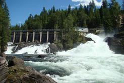
SHUSWAP FALLS
Shuswap Falls at the Wilsey Dam site is an excellent place for a picnic. You may take a walk on several trails and observe a working hydroelectric dam. Shuswap Falls is a maintained BC Hydro Recreation site with a parking lot, picnic tables, interpretive signs, and pit toilets. There is a great viewing platform that overhangs the spillway offering a 'bird's-eye-view' of the falls and dam. During the spring runoff the roar of the water can be heard from quite a distance. To travel to the Shuswap Falls Recreation site from Lumby, head north on Shuswap Avenue, the name of the road changing to Mabel Lake Road on the outskirts of the Village. Follow Mabel Lake Road for 15 km from Lumby to a bridge that crosses over the Shuswap River. After crossing the bridge, drive another 500 metres to the turnoff on your left. The parking lot gate is open from May to October, 8:00 am to 8:00 pm.
Here are some of our most popular water based recreation areas: